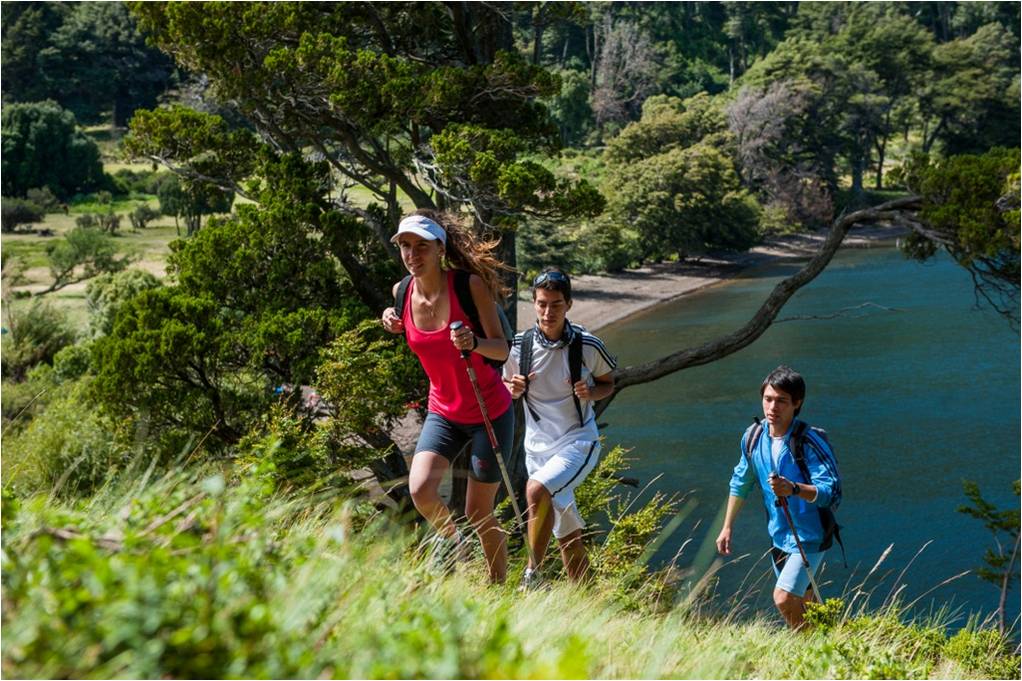
Andean Circuit
The Andean Circuit is the first long-distance trail in Argentina, located in the northern Patagonian mountains.
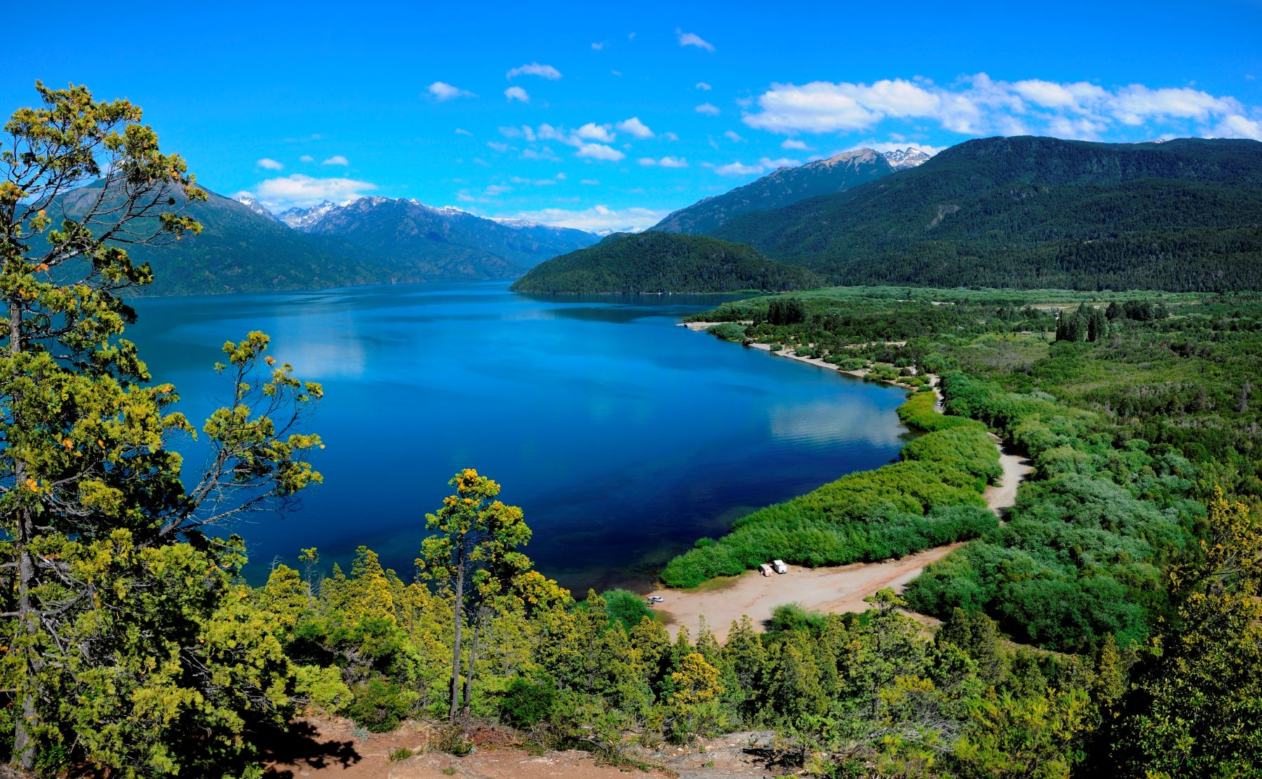
This is a 570-kilometer trunk trail that connects Lake Aluminé in the north with Lake Baguilt in the far south. It runs through the provinces of Neuquén, Río Negro, and Chubut, and allows visitors to visit five National Parks: Lanín, Nahuel Huapi, “Los Arrayanes”, Lake Puelo, and “Los Alerces.”
This trail also passes through the Andean North Patagonian Biosphere Reserve, declared a UNESCO World Heritage Site in 2007.
The trail is primarily designed for less experienced hikers, and each stage has a designated difficulty level (low, medium, and high), with options tailored to each level. It is recognizable by its distinctive markings, which are accompanied by signs at the beginning of each stage and brochures with more detailed information by area, which are distributed at the corresponding information offices.
RECOMMENDATIONS
- You should always check the status of the stage at the information offices of the municipal tourism departments and National Parks.
- See registration methods.
- Choose stages according to your level of experience and physical condition.
- Before setting out, find out about trail conditions, weather conditions, safety, entry times for stages, etc.
- Start your hike early in the morning; the stages are long, so you can be sure to enjoy the walk and arrive at your destination in daylight.
- Stage times are estimates and only include the net walking time. Stops (rests, taking photos, meals, etc.) must be added to calculate the total time.
- Ask about the location of camping areas and available fire pits.
- Fires should only be lit in permitted areas. Check in advance to determine which sites are permitted.
- If you make a fire, make sure you put it out properly before leaving.
- Do not smoke or light fires on the trail.
- Before leaving, remember to fill up with water and always carry at least 2 liters per person.
- Remember that there is no cellphone service on most routes, so do not rely on this as a guarantee of safety.
- Do not enter the trail with pets.
- Please return with any rubbish you generate during your trip. Please keep the surroundings as you found them upon arrival and leave no trace of your visit.
- Walk with someone, never go alone.
NEUQUÉN
1. “Villa Pehuenia” – “Moquehue”
- Distance: 14.5km.
- Duration: 6 hours.
- Difficulty: Medium.
- Seasonality: All year round. Check trail conditions before heading out in winter.
- Points of interest: Puel Mapuche community, “Verde,” “Ralihuen,” “Pichún,” and “Matehue” lagoons, beaches and viewpoints. Icalma Pass. Mahuida Batea National Park.
Description from North to South: The trail begins at the bridge over Lake Aluminé Narrows. We will cross a gently sloping pehuenes forest along a country road. After 1.7 km, we will pass near the shore of Lake Aluminé with an excellent view of “Villa Pehuenia.” We will follow the path to find the information office and the entrance to the Lof Mapuche Puel. Further on, we will take the path to the right, passing Kechulafquen lagoon, which will be on our right. Between the lagoons lies the Kechulafquen Campsite, where we can also see the various artisanal products and sweets manufactured by the Puel community. Thematic guided tour services are also available along the community trails. We will then find a village belonging to the Mapuche Puel community located between two small lagoons. A little further on, we will see Matethue Lagoon on our right; it is the largest lagoon in the area. The path will turn to our right towards the shore of lake Moquehue, where a beautiful beach will invite us to take a break. We will wade through the “Blanco” stream near the coast to continue southwest to Moquehue. The trail will pass through forests of pehuenes mixed with cypresses, lengas, and ñires, showing their ecotonal transition. It will gradually become a faint path with low vegetation of ñires and coirones, always skirting the slope. At one point, we will pass through loose, crumbling volcanic pozzolan soil (walk carefully with a foothold). We will pass by an old warehouse and later arrive at the organized Trenel campsite with full services. If you plan to stay at this campsite, notify the campsite owner of your arrival, who will contact the tourist office. Distance to Moquehue: 1.5 km from the Trenel campsite.
2. “Moquehue” – “Puesto Viejo”
- Distance: 12.5km
- Duration: 6 hours.
- Difficulty: High.
- Seasonality: December – March.
- Points of interest: Pehuenes Forests, old logging roads, views of “Lanín.”
Description from North to South: Cross the Quillahue river bridge and take a local road that leads off to the right. We will ascend until we reach a small clearing at 1,250 meters. From there, two paths lead off, we will take the straight one that leads uphill and walk along it for about 600 meters (15 minutes) until we reach a crossroads where there are vehicle tracks. Turn right (south) along the vehicle track. The path winds along the slope. At 1,300 meters (distance), we will come across a similar path that goes down to the right, but we will stay on it, turning left. We will continue along the forest road until we reach a channel of loose, light-colored stones where the vehicle track ends. From there, the road turns into a trail that climbs through an open forest of pehuenes with no low vegetation or undergrowth. Upon reaching the area of the stunted lenga trees, we will go around it on the right and ascend in a straightforward manner to the pass or ridge of “Cerro Plomo” at 1850 meters above sea level.
From the small pass, we will descend to the right, where we will see some small, clear, rocky outcrops. We will head right through some small clearings to find the trailhead between the scrubby lenga trees. We will descend through the lenga trees and the streambed until we find an old logging road that runs down the left bank of the “Blanco” stream. 3 kilometers from the pass, we will find the old logging station where we can bivouac and continue the next day.
3. “Puesto Viejo” – “Ñorquinco”
- Distance: 11.3km
- Duration: 4 hours.
- Difficulty: Low.
- Seasonality: December – March.
- Points of interest: Pehuenes Forests, old logging roads, Lake Ñorquinco. Columnar basalts, volcanoes.
Description from North to South: After spending the night at the “Puerto Viejo” Bivouac, we will continue our journey, always descending along the left bank of the “Blanco” stream. The path has gentle slopes and after about 2 km, it will open up into a plain with low vegetation. We will reach a coirones grassland area where we will find a crossroad. We will go down to the crossroad and continue the descent taking the path on the left, always heading south. From this point it will be about 4 km until we reach the route. We will pass some squares with two gates and continue the descent along a dirt road for vehicles. Finally, we will reach the pampas that will take us directly to the supply store, after crossing the “Blanco” stream ford, about 100 meters from Route 11 that connects “Ñorquinco” with “Moquehue.”
4. “Ñorquinco” – “Pampa de Castro” Bivouac
- Distance: 15km
- Duration: 6 hours.
- Difficulty: Medium.
- Seasonality: November – May
- Points of interest: Cultural: “Ñorquinco” and “Aigo” Mapuche communities. Natural: Lakes “Ñorquinco” and “Nompehuen,” “Coloco” waterfall, “Clugnu Chompiru” volcano.
Description from North to South: After passing through the “Ñorquinco” information center, where we can obtain the latest information and check out, we will head to the stage entrance on the way to the day-use area at the eastern head of the lake. There we will begin the hike, passing in front of the Park Ranger section, spending the first two hours on the shores of Lake “Ñorquinco.” In this coastal area, we will have the opportunity to see two waterfalls adjacent to the trail, a result of a stone buttress that frames the path. Then, leaving the lake, the trail begins to ascend south, passing through some grassy meadows until reaching a path that takes us to the “Coloco” waterfall, located below on the right. We will then pass through a Ñirantal forest recovering from the fire of 1985. We are always accompanied by a mixed forest of araucaria trees, coihue trees, and pellín oaks. After about five hours of hiking, we will reach the highest point of the pass. We will cross a highland wetland called the Chufquen wetlands, and then arrive at “Pampa de Castro,” where the overnight stay is located (6 hours/15 km). During this stage, waterways can be found at least every two hours.
5. “Pampa de Castro” Bivouac – Lake “Rucachoroi”
- Distance: 14.8km
- Duration: 6 hours.
- Difficulty: Low.
- Seasonality: November – May
- Points of interest: Cultural Aigo Mapuche community, lake “Rucachoroi,” “Pampa de Calfiquitra” transhumance and “Calfiquitra” stream.
Description from North to South: After an overnight stay at the Pampa de Castro bivouac, the stage continues toward Lake Rucachoroi. The first two kilometers of the trail descend into the wide valley of the Calfiquitra Stream, characterized by a forest of pehuenes or araucarias. During the hike, you can see numerous summer outposts belonging to the Aigo Mapuche community, as cattle transhumance is practiced in this area. At the western headwaters of lake Rucachoroi, you will find a rural campsite with supplies. At the end of the stage, you will find the organized campsite of the Aigo community, with supplies, restrooms, dormitories, bicycle rentals, etc. A little further on, you will find the information center and the park ranger station where you can report your arrival. Water is not a problem at this stage, as the route is almost entirely along the southern bank of the Calfiquitra Stream.
6. Lake “Rucachoroi” – “Malalco Chico” Bivouac
- Distance: 11.8km
- Duration: 6 hours.
- Difficulty: Medium.
- Seasonality: December – March.
- Points of interest: Aigo Mapuche Community, Lake “Rucachoroi” Viewpoint, “Calfiquitra” Valley.
Description from North to South: The stage begins at the “Rucachoroi” information center (open from December to February) where we must complete the mandatory registration for the exit or in the Park Ranger section. We will head out towards the campsite. 100 meters from the information center, we will find the “Rucaco” stream, there we will turn left and ascend. The trail runs for the first 2 hours (4 km) through an exclusive araucaria forest gaining altitude, then at 1550 meters above sea level, a traverse of another 2 hours (4 km) begins through an area of short lenga trees. The panoramic views are very beautiful, allowing us to appreciate the “Clugnu Chompirú” volcano and Lake “Rucachoroi,” then entering the high mountain environment of scree and low vegetation at an average altitude of 1800 meters above sea level where the “Cerro Rucachoroi” is surrounded by its eastern slope with a duration of 2 hours (4 km). At the end of the trek, you will find the “Malalco Chico” wetlands, where you will find water. This is the end of the stage, and the overnight site or bivouac is located there.
Those with trekking experience can choose to complete the section in a single day, without a tent, but with enough clothing and a sleeping bag for any eventuality.
At this stage, water can be supplied every 2 hours.
7. “Malalco Chico” Bivouac – Lake “Quillén”
- Distance: 9.4km
- Duration: 4.5 hours.
- Difficulty: High.
- Seasonality: December – March.
- Points of interest: Natural: “Lanín” Volcano Viewpoint and Lake “Quillén.” Cultural: Mapuche Communities.
Description from North to South: After spending the night at the “Malalco Chico” Bivouac, the descent begins toward “Quillén” from 1,750 meters above sea level to 1,050 meters above sea level. The trail runs through areas of short lenga, tall lenga and araucaria forests, and then reaches 1,300 meters above sea level with a ñire forest. This trek takes 3 hours (6 km) and is of high difficulty due to the steep slope, which is very tiring, especially on the descents. The use of walking sticks is recommended. Upon reaching the “Malalco Grande” stream (in the valley), you must ford the stream at the “Lefiman” community. This community has some supplies and lodging options. From there, it is only 1 hour (3 km) by road to the end of the stage, located in “Casa de Piedra” (former park ranger station). You can stock up on water at least every 2 hours. It is open from December to March. You must notify the “Quillén” information center or Park Ranger Section upon arrival.
8. “Puerto Canoa” – South Face of “Lanín” Volcano
- Distance: 20 km round trip.
- Duration: 9 hours.
- Difficulty: High.
- Seasonality: December – April
- Points of interest: Views of the “Lanín” Volcano glacier on its south face, Pehuenes. Panoramic views of lakes “Huechulaufquen” and “Paimún,” and the “Lafquenche” and “Raquitue” Mapuche communities.
Description from North to South: Starting from the Information Center, we will pass in front of the Park Ranger house and turn toward “Lanín” Volcano. We will cross a vast plain of cypress trees crisscrossed by small streams. Always with the silhouette of “Lanín” Volcano in front of us, we will walk for approximately an hour until we cross a stream over a rustic bridge. Here begins a forest of tall trees, called coihues of the genus Nothofagus.
The trail heads to the right toward the “Rucu Leufú” stream bed. This is an area of stony ground where the first Pehuen specimens appear. At one point, we will cross a small branch of the stream to the right, continue along the path, and cross it again to the left to begin the climb through the caracoles that run through a tall forest of coihue and lenga trees. The trail climbs considerably until reaching the short lenga trees. Crossing through them, we will come to the high-altitude mallines, where we can see a waterfall at the end. Crossing the stream is the end of the stage. The view from here is magnificent; a glacial peak on the south face shows us the ascent route called “Colada Mazoldi,” in honor of the first climber to complete it. After resting in the area, we will begin the return route along the same ascent.
9. “Puerto Canoa” – “Aila”
- Distance: 8.2km.
- Duration: 3 hours.
- Difficulty: Low.
- Seasonality: November – April
- Points of interest: Panoramic views of “Lanín” volcano, Lake “Paimún.”
Description from South to North: We will head to the narrow passage between lake “Paimún” and lake “Huechulafquen,” located about 2 km from the “Puerto Canoa” information center. There, we will ring the bell on the shore to alert a resident to pick us up in the boat, allowing us to cross the narrow lake. The trail progresses through the forest on a gentle incline. We will cross very muddy areas where we will find footbridges and several small bridges over streams. The trail flattens out and allows us to enjoy the walk among the araucaria and coihue trees. Near the end, it crosses a couple of extensive plains with good views of Lake “Paimún.” We will cross the “Rimeco” Stream over a log bridge and soon arrive at the “Aila” Village, where there is a campsite. Here, the view of the “Lanín” Volcano is one of the most fantastic in the area.
10. “Aila” – “Epulafquen” Hot Springs
- Distance: 15.1km.
- Duration: 8 hours.
- Difficulty: Medium.
- Seasonality: November – April
- Points of interest: Thermal complex, contact with residents, “Lanín” view, “Los Ángeles” hill range, “Carirriñe” pass.
Description from North to South: After spending the night at the town of “Aila,” we cross the bridge over the “Rimeco” Stream and continue south, always keeping Lake “Paimún” on our right. The trail maintains altitude and runs mostly through a forested area. Upon reaching the southern head of the lake, we will find a plains area where we can see an old steam engine called a “locomóvil” used for forestry purposes. Here we must pay attention to the markings to direct the trail to “Paso Carirriñe.” We will have to cross several waterways and marshy areas. The vegetation is densely wooded and with reed beds, near the route, we will pass through an upper area of a deep ravine, descend to the “Burriquete” stream and cross it (we recommend crossing through the water). Then, a flat section and a small climb that leads to Route 62, the gravel road “Paso Carirriñe.” Here, we will turn left to descend the trail toward the Oconi River bridge. If we continue for about 800 meters more, we will find the Hot Springs campsite, where there are restrooms, a grocery store, and a dining hall. The entrance to the “Epulafquen” Hot Springs Theme Trail is also located there, and it leads us to hot spring pools, where we can take a restorative bath.
11. “Epulafquen” Hot Springs – “Laguna Verde”
- Distance: 13km.
- Duration: 5 hours.
- Difficulty: Low.
- Seasonality: November – April
- Points of interest: Thermal circuit, bodies of water, slag heap, “Laguna Verde,” lake “Curruhue.”
Description from North to South: We start in front of the hot springs Park Ranger’s house along Route 62 heading east. This is a connecting stage, but the road is entertaining and has many interesting sights to see. Although the route has little traffic, caution should be exercised with vehicles. Along our route, we can see the waters of lakes “Carilafquen” and “Epulafquen” to our left. In this area, there is an access to see the “Carilafquen” waterfall between the two lakes. The path runs through a wooded area with magnificent specimens of raulí trees, then we will reach the “Escorial.” It is worth stopping to observe this lava formation generated by the eruption of the “Achen Ñiyeu” volcano that flowed down to lake “Epulaufquen.” We will continue along the route towards “Laguna Verde,” the path passes near a small body of water called “Laguna el Toro.” We will find a bridge nearby. Crossing this bridge, we will find the “Laguna Verde” organized campsite, located between the road and the lagoon of the same name. Upon entering, we will find the sandy beaches of “Laguna Verde.” Continuing along the road, we will find the “Curruhue Grande” lake day-use area, where we will find table service, supplies, and meals.
Notify the campsite staff of your arrival.
12. “Laguna Verde” – “Rincón de los Pinos”
- Distance: 16.2km.
- Duration: 7 hours.
- Difficulty: High.
- Seasonality: December – March 8th.
- Points of interest: “Laguna Verde,” “Escorial,” waterfall, spectacular view of the “Lanín” volcano, “Achen Ñiyeu” volcanoes, araucaria forest, araucaria bifida, “Auquinco” valley.
Description from North to South: Leaving the “Laguna Verde” campsite, we will follow the trailhead along the lagoon following the signs before reaching the “Escorial.” We will turn left, leaving the lagoon behind, enter an area of tall forest, and continue on a gentle ascent, always with the “Escorial” on our right. After two hours of walking, we will reach a large valley dominated by the figure of the “Achen Ñiyeu” volcano, on our right, crossed by a stream that we will have to go through. The landscape here is very distinctive, formed by large expanses of volcanic sand that give it a certain “lunar” air. The views of the “Lanín” volcano and Lake “Epulaufquen” are fantastic. The trail continues gently ascending through plains until we cross the stream again. To our right, we can see the imposing waterfall that descends from the “Achen Ñiyeu” volcano. We then begin the climb through the volcanic sandbank that leads to the “Auquinco” small pass. After crossing the small pass, we will wade through the headwaters of a stream that flows from it. We descend toward the valley floor through a tall forest of mixed coihue, lenga, and pehuen trees, as well as through tall reed beds. At the bottom of the valley, we will encounter a stream with two small but fast-flowing branches; it is best to cross them one at a time. The path then eases, and soon, after crossing some grassy plains, we will come across a huge araucaria tree with two feet. A little further on, we will come across the “Rincón de los Pinos” shelter. Here, we must be careful to open the shelter and ventilate it well for about 30 minutes before entering, wearing glasses and a mask or handkerchief. Check for traces of rodents inside, sweep, and clean utensils thoroughly. It is recommended to set up your tent outside.
13. 14“Rincón de los Pinos” – “Auquinco”
- Distance: 11.5km.
- Duration: 6 hours.
- Difficulty: Low.
- Seasonality: December – March 8th.
- Points of interest: Pehuenes, “Auquinco” Valley, wide views, Lake “Lolog” Coast.
Description from North to South: We will leave the refuge heading toward lake “Lolog,” but not before closing it and removing any food scraps. To our left, the “Auquinco” River and the large wetlands that border it flow down. The trail climbs slightly along the wooded slope, passing several small streams and puddles. We will then begin the descent into the wide valley of the “Auquinco” river. Once on the plain, we will find the first ford of this river. We will continue along the valley and cross the stream, a minor tributary of the “Auquinco.” We will enter a burned area. The path leads us to the second ford of the “Auquinco” river, but this time we will have a suspended footbridge. Continuing along the path, we will find a fork in the paths. The one on our left leads us to “Puerto Arturo,” and the one on the right to the “Auquinco” outpost. We will cross another footbridge over the river and will be very close to the “Auquinco” refuge (free), located on the shores of lake “Lolog.” You can spend the night inside, but it is advisable to air out the area beforehand or set up your tent outside.
It has a fireplace and an ecological dry toilet.
14. “Puerto Auquinco” – “Puerto Arturo”
- Distance: 12.6km.
- Duration: 6 hours.
- Difficulty: Medium.
- Seasonality: December – March 8th.
- Points of interest: “Auquinco” River, “Playa Bonita,” “Puerto Arturo,” Lake “Lolog.”
Description from West to East: We will leave the “Auquinco” outpost, as if returning to “Rincón de los Pinos,” we will cross the hanging footbridge, advance about 400 meters and we will find a path junction marked with signs, we will take the one on the right that says “to Puerto Arturo.” Continuing along the path, we will pass through a low forest of ñire trees and we will always skirt parallel to lake “Lolog,” which will be on our right, later we will arrive at a tall forest where we will cross a couple of minor streams equipped with small bridges, we will arrive at “Playa Bonita” where we will find a bridge made of large logs with handrails. Once we cross the stream, we will pass through a day-use area with a beach, the climb “La Cuesta de la Pava” immediately begins and it is a steep and very eroded climb that will take us to overcome the walls that descend to the lake in that sector. We will descend and then climb another steep slope, then skirt a tall coihue forest. The trail descends gently along a wide path to the Park Ranger’s section at “Puerto Arturo,” where we will find the campsite where the stage ends. Report your arrival at the section or leave a message on the noticeboard. From there, a vehicle road will take us to Route 62, located 4 km away. 6.5 km further on is the town of “Lolog,” the head of the lake, where public transportation arrives.
15. “Puerto Arturo” – “Laguna Rosales”
- Distance: 15km. (10.5km to the town of “Lolog” + 4.5km to Rosales).
- Duration: 4 hours (2.5 km to the town of “Lolog” + 1.5 km to Rosales).
- Difficulty: Low.
- Seasonality: All year round.
- Points of interest: Beaches on the north and east coast of Lake “Lolog,” “Villa Lolog,” “Quilquihue” River.
Description from North to South: This is a connecting stop that links “Puerto Arturo” with the entrance to “Laguna Rosales.” After registering at the station, we will head to route 62, which is 4 km away, following the access road. Once on route 62, we will turn right to follow the northern shore of Lake “Lolog.” We will pass numerous beaches until we reach the eastern head of the lake, 10.5 km from “Puerto Arturo,” where we will find an urbanized area. There, we will cross the “Quilquihue” River bridge, where we will see a section of cabins, and about 200 meters further on, we will find a bus stop, a restaurant, and the access road to the beautiful “Playa Bonita” (a beach of fine sand and warm waters). We can take the bus from here and get off at the entrance to “Laguna Rosales,” or we can walk along route 62 for about 4.5 km toward San Martín de los Andes, where we will find a sign indicating the next stop. Adjacent to the park is the “Kaleuche” neighborhood, which offers a hostel and a little shop. Horseback riding, mountain biking, and hiking services are available.
Notify of your arrival at “Lanín” National Park.
16. “Laguna Rosales” – San Martín de los Andes
- Distance: 14km.
- Duration: 4 hours.
- Difficulty: Low.
- Seasonality: All year round.
- Points of interest: “Laguna Rosales,” wetland, birdwatching, panoramic view of the “Piedra de Trompul” valley. Intercultural neighborhood, mountain bike circuit, panoramic views, Lake “Lacar.” “Curruhuinca” Community.
Description from North to South: The head is located at the intersection of the road to “Lolog” and the entrance to the “Kaleuche” Neighborhood, in front of the “Vialidad Provincial” campsite. At 200 meters, we will find the access gate to the National Park Reserve and the Argentine Army. We will pass through and leave the gate closed. About 300 meters ahead, we will take a detour to the right, then another detour to the right, along a narrow path. Following the marks, we will find a vehicle track and arrive at the beautiful “Laguna Rosales,” where we can see a quantity of migratory birds. The road surrounds it, leaving it to the right, and we will arrive at a viewpoint where we can see the sacred stone of “Trompul.” Then, we will turn through the viewpoint and continue along the path that will take us to a gate on a dirt road. We will cross it and turn right to go down to the “Cull Rain” stream. We will cross it and continue through a wide plain until we reach a gate on route number 48 that goes from San Martín de los Andes to “Hua Hum.” We will cross it, following the marks crossing the mountain bike circuit. The path always continues descending. We will skirt a fence until we reach a gravel road. We will turn right and pass in front of the Park Ranger’s House. About 200 meters further on, we will find a brand-new restroom and supply store, where we can use the public area with excellent views of San Martín de los Andes. After taking a break, we can continue along the path that skirts “Cerro Curruhuinca” for about 3.8 km until we reach a gate where the community charges an entrance fee. We will turn left, descending and always following the signs. Here, the path descends until we reach the level of lake Lacar. We will pass in front of a water treatment plant and then reach the “Juez del Valle” Bridge. Here, we will take Roca street until we reach San Martín square, where the “Parque Lanín” museum and the Tourism Secretariat of San Martín de los Andes are located. This trail can be done by mountain bike in the Rosales – San Martín de los Andes direction, but it has very technical sections, only for experts on the descent to lake Lacar.

17. “Quila Quina” – “Puerto de Casanova”
- Distance: 10.3km.
- Duration: 3.5 hours.
- Difficulty: Low.
- Seasonality: All year round.
- Points of interest: Lake Lacar, Abanico hill (basalt columns), “Quila Quina” beach, Territory of the “Curruhuinca” Community, “Arroyo Grande,” waterfall of the same name.
Description from North to South: The first part is the lake connection to the “Quila Quina” dock. If we travel by land, we must pay attention to the sign located on the path down to “Quila Quina” (final part). At the “Quila Quina” dock, you can hire a horseback ride or a guide from the “Curruhuinca” Mapuche community to accompany you on this interesting journey. “Quila Quina” is a territory that promotes interculturality, filled with stories and legends of the Mapuche people who have inhabited these lands since immemorial times. The trail begins on the street that leads to the dock and begins to climb along well-marked paths, gaining altitude. It passes beside a beautiful waterfall formed by the large stream and then goes around the houses where the community members live. The trail slowly climbs through cliffs and dirt roads, always with the stream on your right. At one point, we will descend to cross a small stream over a fallen tree trunk and then cross an open plain. We will return to the vehicle track to pass several gates, which we must leave closed to prevent the villagers’ cows from escaping.
After the third gate, we will arrive at the Casanova settlement, made up of native Creoles who arrived in these areas at the beginning of the last century. There, we can spend the night at the campsite, stay in a dome, and visit a huge waterfall near the settlement. Ask about the additional services provided by the settlement.
18. Casanova’s Post – “Ruca Ñire”
- Distance: 15.7km.
- Duration: 7 hours.
- Difficulty: Medium.
- Seasonality: Year-round. Inquire in advance in winter because there may be snow on the pass.
- Points of interest: If you spend the night at “Puerto Casanova,” please inform the local through the “Lanín” National Park.
Description from SOUTH to NORTH: We will leave the town of Casanova by vehicle. After 800 meters, we will cross “Arroyo Grande” and continue along the road. About 3 km towards “Lago Escondido,” we will find a sign indicating the way to “Ruca Ñire.” Once we cross a small stream, we will begin a steep climb for about 20 minutes, then the trail eases off at the pass. We will find “Laguna El Toro,” which we will leave on our right, passing through a tall forest of coihues, oaks, and raulís. The path will curve to the left and then begin a steep descent along a dirt road for 2.5 km until we reach the shore of lake “Lacar,” where we will find a beautiful beach to take a break. The trail then continues along the lake’s shoreline. We will cross two streams on log bridges and have access to several beaches on the lake until we reach the “Ruca Ñire” plain, where we will find an overnight area equipped with a firepit, an ecological dry toilet, an overnight dome (large structural tent), and a beautiful sandy beach sheltered from the wind.
19. “Ruca Ñire” – “Hua Hum”
- Distance: 14km.
- Duration: 4 hours.
- Difficulty: Low.
- Seasonality: All year round.
- Points of interest: Beaches, history, contact with Creole residents, lakes “Lacar” and “Nonthue,” waterfall, “Van Dorsen” interpretation center, “Hua Hum” river.
Description from SOUTH to NORTH: Starting from “Ruca Ñire,” we will begin a gentle ascent until we reach a fork of the trail. We will turn right, maintaining the level. The trail has minor ups and downs, with good views of lake “Lacar” and beginning to see typical plant specimens of the Valdivian rainforest (“palo santo,” myrtles, woody vines, large ferns). Then the trail widens and begins the descent towards “Paraje Pucará,” passing through the town of Castro and the Park Ranger of “Pucará.” Then report your arrival at the section. A few meters further on, we will come to the “Pucará” wild campsite with a supply store and restrooms. We continue towards Chachín, crossing the “Pucará” hanging footbridge and then following a vehicle road for 4.5 km. At Chachín, we will find a small supply store owned by the Hernández resident and a free camping area above the lake. Crossing the “Chachín” Bridge, the trail will leave the vehicle road and lead us to a beautiful beach called “Puerto Elvira,” then begin to ascend through a tall forest, crossing the vehicle road twice until reaching the bridge over the “Hua Hum” River, where we will find the Don Bartolo Campsite.
After crossing the bridge, 300 meters away, we will find the “Van Dorser” information center, where we will report our arrival.
20. “Villa Traful” – “Cataratas” Campsite
- Distance: 9.2km.
- Duration: 2.5 hours.
- Difficulty: Low.
- Seasonality: All year round.
- Points of interest: Lake “Traful,” “Villa Traful.”
Description from North to South: This is a connecting stage that links the commune of “Villa Traful” with the “Arroyo Cataratas” campsite, located on Provincial Route 65. The trail runs parallel to the route and at times crosses it to go above it, or along the beach. It initially crosses a tall forest of coihues and cypresses to “Piedra Mala,” where a forest of lower vegetation begins. There we will find the “Arroyo Cataratas” campsite, where the next stage begins. We must notify the Lagos family at the campsite.
21. “Cataratas” Campsite – “Tapera de Lagos” Bivouac
- Distance: 14km.
- Duration: 5 hours.
- Difficulty: High.
- Seasonality: December – May; May – October, exclusively with a mountain guide.
- Points of interest: Summer pasture for livestock use.
Description from North to South: The trail begins at the “Cataratas” wild campsite on Provincial Route 65, 9 km from “Villa Traful.” We will begin the hike by ascending for approximately 45 minutes until we come to a fence. We will cross it and continue through a ñire forest for approximately 45 minutes until we reach the first tributary stream of “Arroyo Cataratas,” called “Las Viejas.” From there, we will continue ascending slightly into the valley and begin to cross “Arroyo Cataratas.” We must cross it 11 times in a period of approximately 3 hours. We will reach a fork, called “La Horqueta.” We will turn right and ascend for approximately two more hours. We will wade through the “Arroyo Cataratas” four more times, and then reach the overnight site known as “Tapera de Lagos.” Fires are only permitted in the central firepit of the “Tapera.” There are no services at this location.
22. “Tapera de Lagos” Bivouac – “Cerro Bayo”
- Distance: 12km.
- Duration: 7 hours.
- Difficulty: High.
- Seasonality: December – April.
- Points of interest: Wild ridges and valleys, ski resort.
Description from North to South: We will start from the “Tapera de Lagos” overnight area and begin a gentle ascent for approximately 1 hour through a lenga forest until it disappears and we reach an open area free of forest vegetation. This section is the watershed between “Arroyo Cataratas” and “Arroyo Ujenco.” We will walk there for approximately 30 minutes. This is the highest section of the trek (1,500 meters above sea level), therefore, there may be snow even during the summer months. Pay attention to the signs. The watershed flattens out, and then we will begin to descend toward the “Arroyo Ujenco” valley and once again enter the lenga forest area. Once there, we will continue descending gently through the valley for approximately 2 hours until we reach a crossing of “Arroyo Ujenco,” where there is a rustic log bridge. From here, the trail always follows the right bank, continuing for approximately 1 hour, through a coihue forest until the trail widens and becomes an unused vehicle road that will lead us to the base of the “Cerro Bayo” ski resort.
The circuit resumes at the “Quetrihué” Isthmus, the entrance to “Los Arrayanes” National Park, in Villa La Angostura, 12 km from this point (6 km to Route 40, then 3 km to the locality center, and then 3 km more to the port area).
23. Angostura – “Arrayanes” Forest
- Distance: 11.5km.
- Duration: 3 hours.
- Difficulty: Medium.
- Seasonality: January – December.
- Points of interest: “Arrayanes” Forest.
Description from North to South: The trail begins at the “Quetrihué” Isthmus, 150 meters from “Bahía Mansa,” in Villa La Angostura. As soon as the trail begins, we will begin to climb. After about 20 minutes, we will reach a viewpoint area with panoramic views of Lake Nahuel Huapi and the Angostura branch. From here, the slope eases, and we will travel along an old cart road that narrows again as we climb a hill at approximately km 8. After passing this hill, the trail descends until we can see “Patagua” Lagoon on the right, an ideal place to rest for a while before continuing. The trail continues, turning 90º to the left and descending to Lake Nahuel Huapi, where we will find the park ranger’s house. A few meters further, we will reach the planked path that runs through the myrtle forest and takes us to the dock. There, we can take a boat to Puerto Pañuelo or return to Villa la Angostura. Once at Puerto Pañuelo, head to Puerto Moreno to connect with “Tambo de Baez.”
RÍO NEGRO
24. “Tambo de Baez” – Jakob Shelter (General San Martín)
- Distance: 16km.
- Duration: 6 hours.
- Difficulty: Medium.
- Seasonality: December – March. The rest of the year is exclusively with a mountain guide.
- Points of interest: Colonia Suiza history, Jakob lagoon, Témpanos lagoon, mountainous surroundings.
Description from North to South: The entrance to the trail is located on the road that connects the “Casa de Piedra” stream with Colonia Suiza (Provincial Route 79). We will travel along a dirt road for about 300 meters, pass a gate, and arrive at a town historically known as “Tambo de Baez.” There is a parking lot at said place. From there, the road gradually ascends, turning into a trail until we approach the shore of the “Casa de Piedra” stream, which we will continue upstream without changing sides. After a half-hour walk, we will enter Nahuel Huapi National Park (PN – “Parque Nacional”) and, continuing along the right bank, we will reach a bridge over the “Casa de Piedra” stream. The trail crosses the bridge and continues along the left bank until, at the bottom of the valley, passing a tall lenga forest, we will begin a rather steep climb called “Los Caracoles.” We will ascend this path until we reach a footbridge that allows us to cross to the other side of the stream and continue the ascent. We will continue climbing until we reach the General San Martín shelter of the Bariloche Andean Club, commonly known as Jakob, named after the lagoon of the same name. This shelter offers overnight accommodation, meals, a camping area, and restrooms.
25. Jakob Shelter – “Los Césares”
- Distance: 19km.
- Duration: 10 hours.
- Difficulty: High.
- Seasonality: Summer. Rest of the year exclusively with a mountain guide.
- Points of interest: Schweitzer Pass, Témpanos Lagoon, bodies of water, panoramic views, contact with residents.
Description from North to South: The trail runs to the right of the lagoon, along some rocky promontories. From the valley floor, we will climb to the Schweizer pass, with magnificent views. The descent is very steep. We will reach the headwaters of the “Casalata” stream. We follow this stream along the left bank. After a couple of hours, we will reach a place where it is possible to camp in case of emergency. We will then reach an area of wetlands, which we will cross on the left. We will then ford the stream and walk along its right bank. After the next ford, we will begin to skirt the area, with views of lake Mascardi. We will descend through a cypress forest to an area near the lake where we will ford the Casalata stream for the last time. From there, the trail is almost flat and through open forest. We will have to ford the Claro stream and cross the Manso river (hanging footbridge). In the “Tres Álamos” area, it is possible to camp and complete the stage. In another half hour, we will reach “Los Césares,” near the road to Tronador or Bariloche. About 15 km south, we will find the “Los Rápidos” (organized) campsite. The start of the next stage is 5 km from “Los Rápidos,” along the road to Bariloche, at the Llodconto Stream, 300 meters before the “La Querencia” (organized) campsite.
26. Lake Mascardi– Lake Steffen
- Distance: 19.5km.
- Duration: 8 hours.
- Difficulty: Medium.
- Seasonality: December – March.
- Points of interest: Bodies of water, contact with residents, Waterfall in the Book Outpost area.
Description from North to South: The trail begins at the access route to “Cerro Tronador” and the Alerces waterfall (Provincial Route 81) at the bridge over the Llodconto stream. Initially, you will ascend along a road reserved for official use only, up to the so-called Boock outpost. From there, a path continues through a gently sloping area. You must ford a stream. This valley has several wetlands that should not be crossed. The trail skirts them on the left side, crossing three or four shallow streams. Then, you will begin to descend through a tall forest of coihue and cypress trees until you reach the Montero family campsite at the eastern head of Lake Steffen, where this stage ends. The next stage continues next to lake Steffen’s park ranger’s house, located 15 minutes from the campsite.
27. Lake Steffen– Villegas
- Distance: 10.5km.
- Duration: 3 hours.
- Difficulty: Low.
- Seasonality: November – April.
- Points of interest: “Huenchupan” Mapuche community, contact with residents, Villegas and Manso rivers, lake Steffen. Bodies of water, contact with residents, Waterfall in Book Outpost area.
Description from North to South: We will begin at Lake Steffen’s Ranger Station. The first part follows the Lower Manso River along a trail, then opens onto a vehicle road. Forty minutes from the station, we will pass the “El Viejo Manzano” wild camping area, with a river bank. The trail begins to separate from the river. We will cross four slow-flowing streams, which can be dry in late summer. Near the confluence of the Manso and Villegas rivers, the trail once again approaches the river. The last part follows a rarely used vehicle track, which joins National Route No. 40 (paved) near the bridge that crosses the Villegas river (the southern boundary of Nahuel Huapi National Park). This stage ends here.
If we want to continue on to the next stage, we must turn right, walking along the shoulder of the road for about 300 meters and then after crossing the bridge and walking another 200 meters, arriving at the Villegas Gendarmerie outpost, in front of which the road to León Pass (gravel) begins. We must take this road and travel along it for about 6 km, passing through the commune of Villegas, until we reach the “Kaleuche” organized campsite (trailhead), located on the coast of the Manso River, in the commune “El Manso.”
28. “Kaleuche” Campsite – “Chacra Santa Lucía”
- Distance: 14km.
- Duration: 5 hours.
- Difficulty: Low.
- Seasonality: All year round (check in advance for the status of the “Coronel” stream and snow accumulation in winter)
- Points of interest: Contact with residents, views of the hills, and cave paintings.
Description from North to South: It begins at the “Kaleuche” organized campsite, on the banks of the “Manso” river. Turn right and after about 100 meters, turn left, heading south along a vehicle road. The path ascends to a good viewpoint over the “Manso” Lower River. Continue through the Colorado swamp along country roads, with views of “Montura” or “Foyel” hill to the west and “Fortaleza” hill to the east. We will reach the “La Piedra” campsite (a cross on a rocky outcrop), adjacent to the town of “Ida Fernández.” Through a cut, we will rejoin the gravel country road and turn right. We will cross the “Coronel” stream over a bridge; a short zigzag climb will take us to “Est. Ayelen.” After crossing it, we will turn left, descending toward the “Coronel” stream, which we must cross (it may be impassable in spring). We will soon be at the “Chacra Santa Lucia” hamlet, where we can find some services. End of the stage.
The stage can be completed by mountain bike, taking into account the slopes according to favorable directionality.

29. “Chacra Santa Lucía” – Perito Moreno
- Distance: 14.7km.
- Duration: 6 hours.
- Difficulty: High.
- Seasonality: Autumn – Summer.
- Points of interest: Contact with residents, panoramic views, banks of the “Foyel” River.
Description from North to South: From “Chacra Santa Lucia,” we will descend to the “Foyel” river. The light blue and white markers will direct us to the fording point. After crossing the river, we will turn left and, about 800 meters further on, we will reach the town of “Troncoso.” From there, we will ascend along a dirt track until we reach the gravel road that leads to “Lago Escondido.” Turning right, we will continue along the path until we reach a cattle guard (cattle grid). 20 meters before the cattle grid, we will turn left to a quarry, which we will cross. We will continue along a track. After a couple of climbs, we will gain panoramic views of the valley, including the flat, wooded “Cerro Fortaleza.”
Most of the remaining route is on flat terrain. We will cross a stream with a higher flow before reaching the fence in the neighboring field. We will follow a wide path that climbs slightly, without taking any detours. At the end, it drops to the left, to the ford of the Pedregoso stream, with a highly variable flow, which we must cross. From there, following the signs, we will turn right until we come to an aqueduct. We will turn left along the edge of it until we reach the gate that leads us to the local road that leads to the Perito Moreno shelter. To reach the shelter, we will turn right; it is 1.8 km uphill.
If the shelter is not available, you can spend the night next to it.
30. Perito Moreno – Wharton
- Distance: 9.4km.
- Duration: 3 hours.
- Difficulty: Low.
- Seasonality: All year round.
- Points of interest: Access to mountain shelters, ski center.
Description from North to South: The stage begins at the intersection of the access road to the Perito Moreno ski resort and the trail (located 1.8 km before the resort). We will head left, descending the path without taking any detours until we reach the Wharton station. We will pass the entrances to various mountain refuges located in the “Río Azul-Lago Escondido” Protected Natural Area.
First, we will pass the access to the “Encanto Blanco” shelter on our right. From Wharton, we will reach the “Cajón del Azul,” “Retamal,” “Natación,” “Hielo Azul,” “Dedo Gordo,” and “Los Laguitos” shelters. Along the route, we can enjoy views of the mountain range to the west and, to the south, the vast “Comarca Andina del paralelo 42.”
31. Wharton – “Río Azul” Campsite
- Distance: 16km.
- Duration: 5 hours.
- Difficulty: Low.
- Seasonality: All year round.
- Points of interest: Panoramic views of the valley and the mountain range, “Cabeza del Indio” viewpoint, access to El Bolsón mountain shelters.
Description from North to South: This is a straightforward stage, except for the climb to the Azul viewpoint, which runs mostly along the valley floor. We will follow the “Costa del Río Azul” local road, following the signs leading south. Approximately 1 km after the entrance to the “Hue Nain” organized campsite, we will leave the local road to join a path through the forest that leads to a secondary road, access to the “Hielo Azul” shelter. Upon rejoining the vehicle road, we will turn left for a few meters and see a trail marked with “Huella Andina” on the right. The path leads through the forest, gradually ascending to the access road to “Cabeza del Indio.” We will turn right into the Azul River Viewpoint, with good views over the valley. From there, we will descend to a crossroads and take the other side, a secondary road that leads to a gravel route. At this point, the path drops steeply to the right, leading to the wild campsite located on the banks of the Azul River, the end of the stage. Through this campsite and across the footbridge, you access the “Cerro Lindo” shelter.
CHUBUT
Section 10 – Stage 32 – Azul River Campsite – Lake Puelo National Park
- Distance: 14.9 km
- Duration: 5 hours
- Difficulty: Low
- Seasonality: All year round.
- Points of interest: Azul River Coast
Description from North to South: Starting from the Azul River campsite, we will descend toward it (without crossing the footbridge), accessing a small path that branches off to the left under the bridge. We will walk with the Azul River on our right, close to its banks. After about 3 km, we will reach the “Quemquemtreu” River, which flows into the Azul River. The river can be easily waded during summer. If the water is high, take a local street to access a bridge over the “Quemquemtreu” River and cross it. We will exit onto the paved road that connects El Bolsón with Lake Puelo, turning right. We will follow it for about 250 meters. We will descend again to the right to the banks of the Azul River, following the old gravel road that is now a local street. Upon reaching the riverbank, we will continue along the river barrier to the “Onda Azul” Hostel. From here, turning left, we will take a local street to Lake Puelo Tourism Office, in the town center. The next stage begins inside Lake Puelo National Park. One option is to walk along the shoulder of the paved road for the 4 km that separate the town from the park; the other is to take public transportation.
Section 10 – Stage 33 – Lake Puelo National Park – “El Desemboque”
- Distance: 12.7 km
- Duration: 7 hours
- Difficulty: High
- Seasonality: Summer.
- Points of interest: panoramic views of Lake Puelo, “Cerro Tres Picos” and Turbio.
Description from North to South: From the Park information office, we will see the access sign for the “Mirador del Lago” trail, which we will take. At the fork, we will continue up the “Sendero del Faldeo” trail, reaching the Maninga stream and the Maninga outpost. The trail passes through the junction that leads to the summit of “Cerro Currumahuida”; we will continue to the right. We are surrounded by a forest of cypress and coihue trees that gives way to a burned area; alternating ups and downs, we will enjoy panoramic views. We will pass through forests in the process of being renewed, climbing to the “La Roca” viewpoint. We will continue to “Las Lagunitas” and a little further on, we will reach the Morro mountain. We will pass it on the right, and a steep descent begins. The trail turns abruptly to the left, and soon we will begin to descend toward the Epuyén River, bordering steep cliffs. We will reach the riverbank and walk 750 meters upstream to the bridge, we will cross it and then go down the other bank to the campsite located on the shore of the lake.
Section 11 – Stage 34 – “El Desemboque” – “Puerto Patriada”
- Distance: 12.3 km
- Duration: 6 hours
- Difficulty: Medium
- Seasonality: January – March
- Points of interest: panoramic views of “Puelo,” “Desemboque,” “Turbio,” “Tres Picos,” Valdivian Rainforest, and Lake Epuyén.
Description from North to South: The trail begins at the “El Desemboque” wild campsite, runs along the coast to the left, and joins the path that leads to the “Turbio” River. Shortly after beginning to ascend, we will come across rocky ground that leads us to the “dangerous stone,” a small viewpoint of Lake Puelo. At that point, the trail turns left and uphill in an easterly direction, leaving behind the path to the “Turbio” River, which runs parallel to the lake. From there, the trail climbs very steeply for an hour until reaching 560 meters above sea level, where we will find a stream. At that point, be careful because we must leave the main path that ascends and turn left along a path that skirts to the north. Further on, we will find granite rocks mixed with low vegetation and cypress trees. We will reach the “Derrumbe” hill pass, where the trail between the “Alerces” and “Derrumbe” lagoons is located. At this junction, head north (left) until you reach the “Alerce” lagoon, a place with a log shelter and fire pits. From this point, the descent begins to the northern shore of Lake Epuyén along an easy trail but with signs of erosion caused by water and traffic. All the services and a camping area are located in “Puerto Patriada,” on the northern shore of Lake Epuyén.
Section 11 – Stage 35 – “Villa Lago Rivadavia” – North Gate
- Distance: 11 km
- Duration: 6.5 hours
- Difficulty: Medium
- Seasonality: January – March
- Points of interest: Natural viewpoints, panoramic views of the Carrileufú Valley and Lake Rivadavia.
Description from North to South: Starting from School No. 103 of “Villa Lago Rivadavia,” located on Route 71, we will walk about 200 meters until we find the sign indicating the start of the stage. The trail climbs along a country road and, after crossing a small stream, takes a path to the right, always ascending, through an open forest of Andean cypress trees. The markings in this area were made by students from the rural school; they are placed on the trees and are colored yellow. Along the trail, we will find log steps, railings, and seats made by the school children, clearly exemplifying the collective spirit of “Huella Andina,” in this case strengthened by the participation of the Cholila Andean Club. The “Huella Andina” markings alternate with the same ones until we reach the first two viewpoints, which allow us to enjoy excellent panoramic views of the “Carrileufú” River valley and the magnificent mountain range in front. The trail continues along the slope, leaving the school markings behind and continuing along the light blue and white paths. It passes another viewpoint, which in this case directs us toward lake Rivadavia Sur, opposite the crowned hill and behind it, “Cerro La Momia.” We will cross a wire fence where a sign welcomes us to “Los Alerces” National Park. The transitional forest gradually transforms into a taller coihue forest. The path crosses some corrals in a village to begin the descent, initially along open or wide paths that later transform into smaller, steeply descending trails until we reach the road in front of the north gate of the National Park, where we will announce our arrival.
Section 11 – Stage 36 – North Gate – “Bahía Solís” Campsite
- Distance: 11 km
- Duration: 7 hours
- Difficulty: Medium
- Seasonality: January – March
- Points of interest: Panoramic views. Access to the Rivadavia River at the end.
Description from North to South: We will begin at the North Gate. There is a bridge on the route over the Hacha stream. Just after crossing it, on the left, we will find the trail entrance sign. It begins as a steep climb and then it reaches a maintained elevation. We will pass through native forests, with gentle slopes and stream crossings. To the west, there is a panoramic view of Lake Rivadavia, until we reach some corrals where we will descend steeply to the “Tres Bahías” campsite. The trail then leads us along the shore of Lake Rivadavia until we reach “Bahía Solís.” The “Bahía Solís” campsite is an organized campsite, and a little further south is a wild campsite managed by residents.
Section 11 – Stage 37 – “Bahía Solís” Campsite – “Arrayanes” Section
- Distance: 14 km
- Duration: 8 hours
- Difficulty: Medium
- Seasonality: January – March
- Points of interest: panoramic views from the “Lago Verde” viewpoint
Description from North to South: We will begin at the “Bahía Solís” organized campsite. Bordering Lake Rivadavia, we will reach the Rivadavia River. Following it, we will reach the Colehual stream, which we will ascend until we cross it via the bridge over the road. We will then continue along an old cart track that leads us to the outskirts of the town of Alarcón. We will cross a nearby stream via a log bridge and continue ascending to the “Lago Verde” viewpoint, crossing the road a couple of times. From the viewpoint, with its beautiful panoramic views, we will continue to the access road to the “Lago Verde” Park Ranger section. A few meters ahead, on the left, we will join the trail that borders “Lago Verde.” We will follow this secluded body of water to the parking lot. Then, along the plank path, we will reach the lower parking lot of the pedestrian bridge over the “Arrayanes” River. We will walk back a few meters until we enter the trail that will lead us to the Park Ranger station and the “Arrayanes” campsite (wild).
Section 11 – Stage 38 – “Arrayanes” Section – “Punta Mattos” Section
- Distance: 11.3 km
- Duration: 6 hours
- Difficulty: Medium
- Seasonality: January – March
- Points of interest: panoramic views
Description from North to South: We will begin at the “Arrayanes” section. We will exit onto the route until we connect with the “Laguna Escondida” trail. The trail ascends steeply and leads us to a lookout point with panoramic views of Lake Menéndez. From there, we will continue up to “Laguna Escondida.” In the vicinity, the trail continues through a native forest, initially flat and then descending, at times steeply, with excellent views of Lake Futalaufquen, near Braese Stream, which we will cross via the trail bridge. We will advance close to its shore and then follow the side of Lake Futalaufquen. We will leave its shore to ascend to a huemul lookout point with views of the “Cerro Riscoso.” Through pampas and old forest tracks, we will first arrive at “Playa del Francés” (free camping) and then, along the lake, we will arrive at the free camping site –for day use only– of “Punta Mattos” (near the Park Ranger station).
Section 12 – Stage 39 – Lake Krügger– “Villa Futalaufquen”
- Distance: 18.6 km
- Duration: 12 hours
- Difficulty: Very high
- Seasonality: January – March
- Points of interest: panoramic views, lake beach
Description from North to South: We will begin at Lake Krügger. After a stretch along the lake, we will begin a gentle climb that leaves us at a stable elevation, then descend to “Playa Blanca,” which we will reach after crossing the stream that flows into it. The path now ascends quite steeply until reaching a pass with incomparable panoramic views. Then, we will have a gentle descent until we cross another stream on the flat surface. Following the flat surface, there is a descent through a reed bed, softened by the zigzag layout. The path skirts views of Lake Futalaufquen until we reach the remains of the “Puesto Rozas” cemetery. From there, we will continue until we find the entrance to the “Cinco Saltos” trail, which we will ignore. The path will lead us to cross a bridge over the “Los Pumas” stream and then join (near “Puerto Limonao”) the coastal road that leads us to “Villa Lago Futalaufquen,” passing through “Puerto Bustillo.” South-North: The only difference is that, in this case, improvised camping is allowed on “Playa Blanca.”
Section 12 – Stage 40
- Distance: 11.4 km
- Duration: 4 hours
- Difficulty: Low
- Seasonality: December to March
- Points of interest: contact with residents, local products of “Villa Futalaufquen”
Description from North to South: After registering at the “Villa Futalaufquen” information center, we will leave and turn right onto the road that leads to School No. 25. At that point, we will turn left and take a flat road through the fields with excellent views of the mountains surrounding the valley until we ford the Cascada Stream. After crossing it, we will quickly reach a gravel road, which we will cross and continue straight ahead. After passing some corrals, we will begin a climb, passing a viewpoint on our left at the end. We will continue across an open plain, from which we will descend near the town of “Pichón Tardón,” next to the Rañinto Stream. After crossing a bridge and crossing its plain, we will ascend gently to enter a small forest. The road remains flat and leads us to the town of “Rodolfo Tardón,” next to the Central Gate.
Section 13 – Stage 41 – “Aldea Escolar” – “Ruca Nehuen”
- Distance: 11.7 km
- Duration: 3.5 hours
- Difficulty: Low
- Seasonality: All year round
- Points of interest: open and panoramic landscapes of the mountain range.
Description from North to South: The trail begins at School No. 96 “Aldea Escolar.” At the first corner of the school, turn right along the local street for about 300 meters, always following the signs on the posts. After several blocks, we will head towards the “Paso Ancho” bridge along a gravel road. The path reaches a fork where we will turn right. About 3 km after the bridge, we will reach the entrance to a local alley called “Callejón de Jones,” allowing us to enjoy our walk even more peacefully. We will encounter areas with marshes, but we can cross them comfortably thanks to the wooden walkways built for “Huella Andina.” We will reach the Baguilt stream, where we will find a wooden bridge that will allow us to cross the stream. We will continue west, where we will find another walkway to avoid another marsh. Then the road turns left along a country road to reach Route 259, where we will find the “Ruca Nehuen” store.
Section 13 – Stage 42 – “Ruca Nehuén” – Lake Baguilt
- Distance: 16 km (one way)
- Duration: 6.5 hours
- Difficulty: High
- Seasonality: September to May.
- Points of interest: views of the “16 de Octubre” Valley, Lake Baguilt, Protected Natural Area.
Description from North to South: The trail begins at the “Ruca Nehuén” site, where there is a store and dining hall along the route. From there, the ascent begins along a dirt road through private fields belonging to the Trevelin ejido (common land). The road is very winding at first; from here, we can see the Futaleufú Dam with the mountain range in the background. Following the light blue and white markings on posts or rocks, we will reach an area where we will see the immense “16 de Octubre” Valley. We will cross two stream fords and arrive at the first gate belonging to a resident. We must leave this gate closed because animals escape. The road ascends steadily, passing an old, abandoned bus and then reaching the gate of the Protected Natural Area. From here, the trail passes through a dense forest of coihue and lenga trees, the understory is dense and well-grown. Upon reaching Lake Baguilt, there are many secondary roads; pay close attention to the markings. The lake is enclosed between enormous rocky mountains and boasts unique beauty. There are also small beach areas. Upon arrival at the lake, inform the park ranger, who will register you and assign you an overnight stay.