“Laguna Blanca” National Park
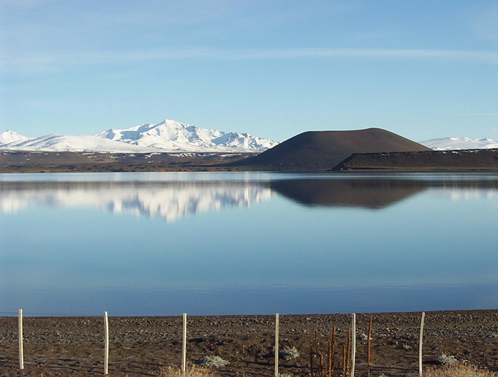
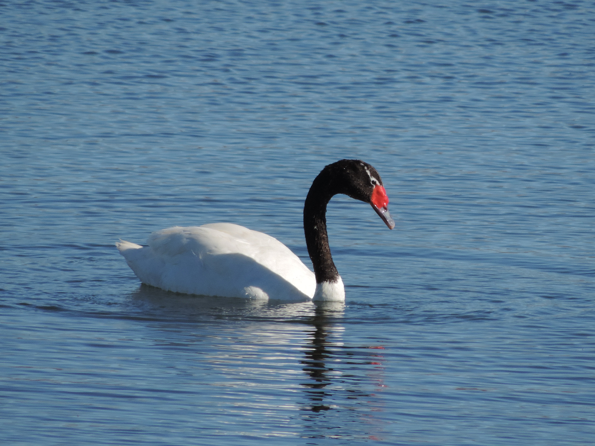
Nestled in a volcanic landscape, “Laguna Blanca” National Park, created in 1945 and covering 11,250 acres, offers a unique environment with ancient volcanoes and scoria (volcanic materials), and one of the largest freshwater bodies in northern Patagonia, where aquatic birds such as flamingos and swans can be observed.
Furthermore, the area has been a meeting place for indigenous communities (Mapuche) and Creole settlers, passing through their summer vacation spots, leaving behind various cultural vestiges that reflect this.
Trails, walks, and viewpoints to appreciate the beauty of the place, and be amazed at every step by the landforms and nature that always opens up.
HOW TO GET THERE
By car
From the city of Neuquén, head east along National Route 22 to Zapala. From there, head south on National Route 40 and then turn right onto Provincial Route 46 to the visitor center (215 km total).
From the city of Mendoza, to the north, via National Route N° 40 and Provincial Route N° 46 (984 km).
From Temuco (Chile), to the west, via the Icalma Pass, Provincial Route 13 and Provincial Route 46 (287 km).
From San Carlos de Bariloche, to the south, via National Route 237, National Route 40 and Provincial Route 46 (376 km).
Other means of transport
In the capital city of Neuquén, which has daily plane connections to Buenos Aires, it is possible to rent a car or visit a travel agency to visit the protected area.
Another option is to reach Zapala by bus and then continue to “Laguna Blanca” by taxi or on the daily buses that depart for the town of Aluminé.
TRAILS
1 – Sendero peatonal interpretativo “Paseo de la Laguna”
The flora and fauna of the Patagonian steppe inhabit this uneven but easily traversable terrain. The walk features seven themed stops designed to interpret nature’s adaptation to the environment. Tiny leaves, deep roots, fleshy stems, dense bushes, and animals (the Patagonian gray fox, the grassland cat, and the piche, among others) coexist along this trail.
- Distance: 700 meters.
- Time: 30 minutes.
- Difficulty: Low.
- Open year round.
2 – “El Resguardo” interpretive pedestrian trail
This short road teaches us about the relationship between ancient settlers and the environment and allows us to learn more about the history of the area. Towards the end, the path leads us to two large rocky eaves that have been used by humans for hundreds of years as a crossing point between the steppe and the mountain range.
- Distance: 50 meters.
- Time: 10 minutes.
- Difficulty: Low.
3 – “Cerro Mellizo Sur” pedestrian trail (a section is proposed)
Volcanic activity shaped the unique landscape of this area. It is an uphill trail where you can observe skunks, choiques, birds, and steppe and high-mountain flora. Underfoot, sandy and stony terrain, eventually crossing basaltic scoria toward the end of the section.
- Distance: 3,600 meters (first section) / 720 m (second section).
- Time: 1 hour 15 minutes.
- Difficulty: Low.
GENERAL TIPS
Before traveling we suggest:
- Check the season and hours of the National Park.
- Admission is free all year round.
“Laguna Blanca” National Park Intendancy: Calle 12 de Julio 686 (8340) – Zapala, Neuquén. Tel.: (+54 2942) 431982 – E-mail: lagunablanca@apn.gob.ar
National Parks Administration: Headquarters – Carlos Pellegrini 657, CABA. Tel: (+54 11) 3985 – 3800 Int. 11010 – E-mail: informes@apn.gob.ar
www.parquesnacionales.gob.ar/areas-protegidas/region-patagonia/pn-laguna-blanca/
- Check road and vehicle conditions
www.argentina.gob.ar/vialidad-nacional/atencion-al-usuario
- Wear comfortable and appropriate clothing according to the time of year: www.smn.gob.ar
- Bring basic supplies.
- Considering this is a natural area, there are snakes, arachnids, and insects in the area. It is recommended to bring repellent and follow the signs.
- Bring binoculars
- There may be no phone signal or Wi-Fi network.
- Get advice on trail difficulty. Inquire about accessibility for people with motor or sensory disabilities.
- Always notify the ranger before starting any trail by registering at the Information Office or Visitor Center.
- Never walk outside the permitted trails.
OTHER ATTRACTIONS TO DISCOVER IN THE AREA
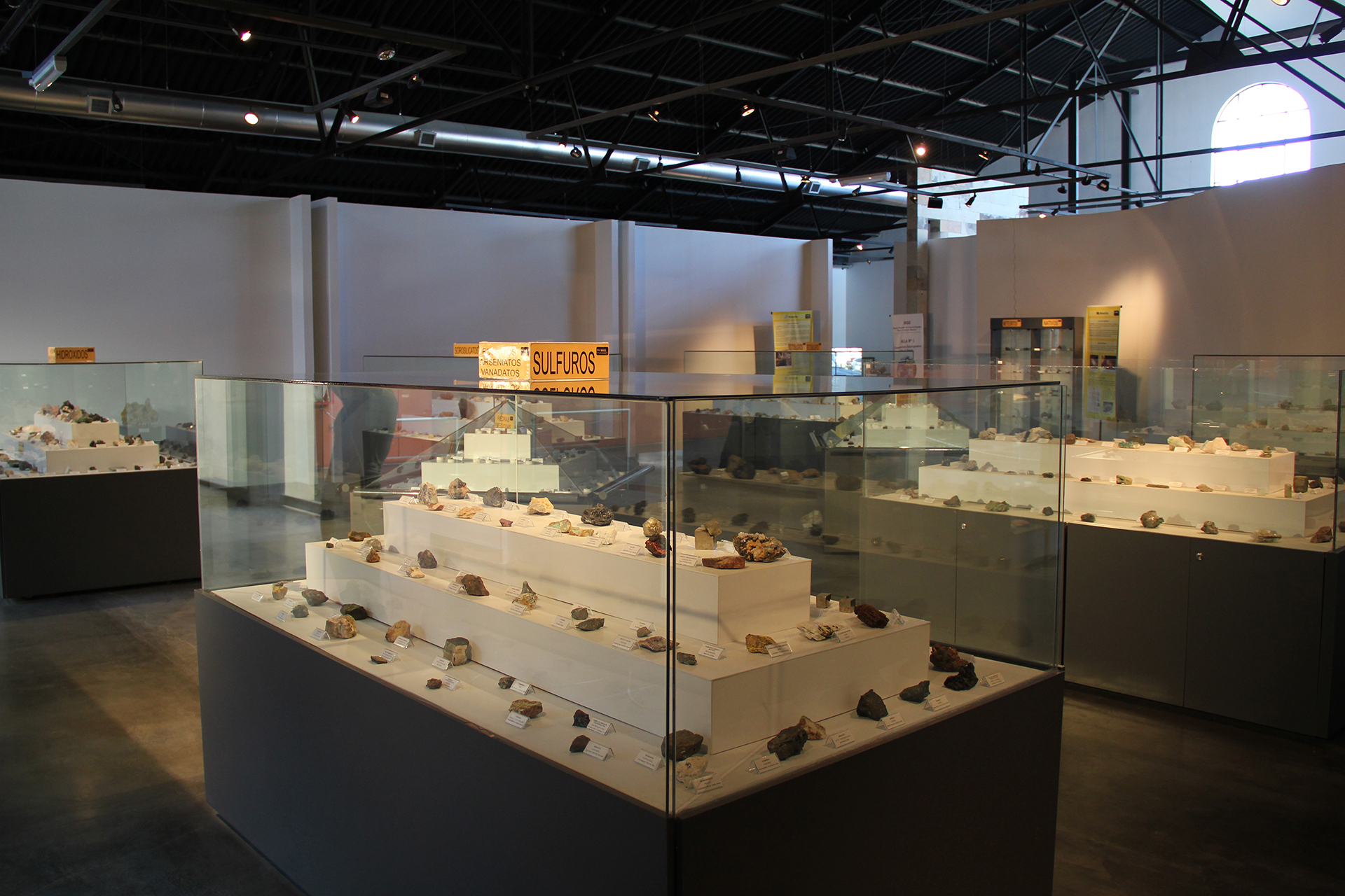
The city of Zapala is located 32 km from the Park. Its name in the Mapuche language means “swampy lagoon.” Here you can visit the Olsacher Provincial Museum of Natural Sciences, one of the city’s most important attractions. It houses a mineral display of more than 2,000 species from 84 countries. It also houses a paleontological exhibition featuring reptiles, plesiosaurs, ichthyosaurs, turtles, and a varied collection of invertebrates found in the surrounding areas of the city.
The crystal-clear waters of the Covunco stream allow you to enjoy a natural spa in the summer, about 19 km from Zapala at the town of Mariano Moreno. In the winter, Primeros Pinos, 49 km from Zapala, provides the possibility of practicing snow sports and games among the mountains and pehuenes.
103 km away is the city of Aluminé. Its name in the Mapuche language means “bright in the depths.” Its landscape is characterized by forests of pehuenes, or Araucaria araucana, an ancient tree that predominates in the area.
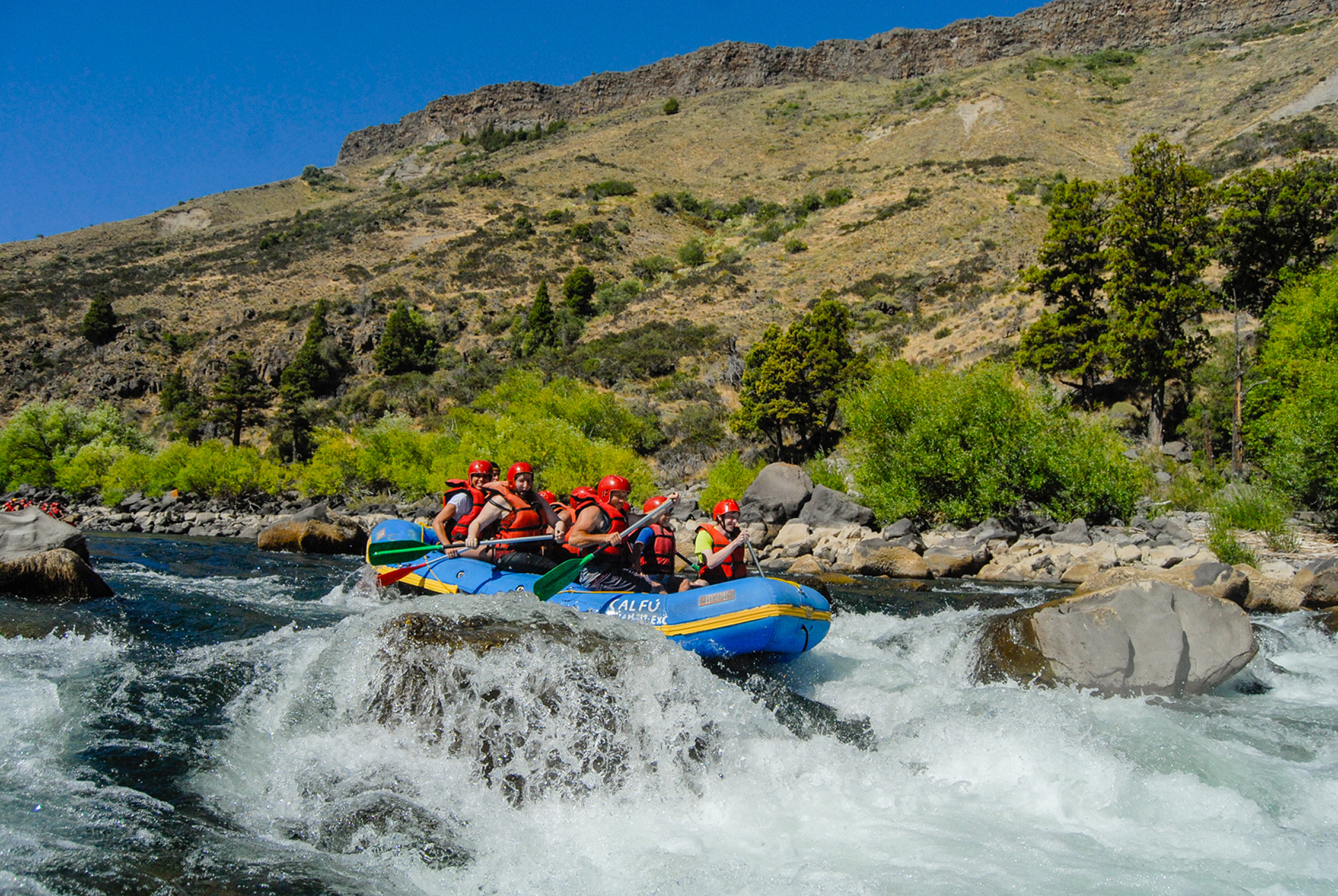
It is one of the best spots for fly fishing. Brown Trout, Rainbow Trout, Brook Trout, and Perch can be caught in every stream and lake. Water sports are also available, such as canoeing and rafting on the rapids of the Aluminé river.
Just 50 km away, you can visit a picturesque 3.3 km2 body of water called lake Ruca Choroy. Along the way, bordering the Choroy River, you will find López lagoon, with its diverse birdlife. You will then pass through the “Paraje Carrilil” and the Aigo Mapuche Community, where traditional handicrafts are sold.
In winter, 65 km away is the “Cerro Batea Mahuida,” a snow park managed by the Mapuche Puel community. Ideal for skiing, snowboarding, sledding, snowmobiling, and more.
WHERE TO STAY
The closest accommodations to the National Park are located in the town of Zapala, 32 km away, and in Aluminé, 120 km away. You can find them on this website:
http://sit.neuquentur.gob.ar/es/sit/alojamiento/busqueda-alojamiento/
Folleto en PDF

