TIERRA DEL FUEGO TRAILS
First, we suggest a trail that offers a novel approach to short circuits, suitable for the whole family, aimed at exploring and interpreting the natural environment and local culture in spaces linked to protected areas.
Tierra del Fuego National Park
The Tierra del Fuego National Park, created in 1960, is the southernmost protected natural area in the Americas. Its 70,000 acres showcase a fusion of environments: sea, Patagonian forests, and mountains.
The National Park is home to a limited variety of wildlife—20 mammal species and 100 bird species—and several exotic species, including beavers, muskrats, rabbits, minks, gray foxes, yellowjackets, salmon, and trout, among others.

The dominant vegetation belongs to the so-called subantarctic or Andean-Patagonian forests. The different types of vegetation found in this region include lenga forests, high Andean steppes, and peat bogs.
It is the only place in our country where the Patagonian-Andean forest reaches the sea.
In this setting, paths meander, and they open the way to emotions, steps that lead to further discoveries of sensations right there at the End of the World.

HOW TO GET THERE
Regular flights and buses arrive in Tierra del Fuego’s capital from various points across the country. You can get there by private vehicle, on an organized tour, or by taking regular bus services.
By car
Only 10 km separate Ushuaia from the National Park. 5 km before the entrance, both National Route 3 and secondary roads are made of dirt. In winter, snow tires or chains are mandatory. In summer, caution should be exercised due to suspended dust.
TRAILS
1 – Lapataia Viewpoint Pedestrian Trail
This short and accessible route offers panoramic views of Lapataia Bay, passing through the fascinating lenga forest, the Tierra del Fuego white oak, a tree representative of the Patagonian-Andean forest. This is where National Route 3 ends, connecting with the Pan-American Highway, a route that runs from one end of our continent to the other.
- Distance: 1 km
- Difficulty: Low
2 – “El Turbal” Pedestrian Trail
Surrounding a typical Fuegian peat bog, the path allows you to observe abandoned beaver dams – constructions made by the beavers that live in the area – along the trail that leads to Lapataia Bay.
- Distance: 2 km
- Difficulty: Low
3 – “Castorera” Pedestrian Trail
Following the course of a stream, you reach a beaver dam. This trail allows you to appreciate the work of beavers, a species introduced in the 1940s that has a significant impact on the ecosystem. They caused significant and visible changes to the landscape, as the felling of trees and the construction of dams altered the morphology and hydrology of the waterways where they operate.
- Distance: 400 m (round trip).
- Difficulty: Low.
4 – “Pampa Alta” Path (closed in winter)
The promise at the end of the trail is impressive panoramic views of the Beagle Channel, the Pipo River Valley, “Cerro Guanaco,” and the Chilean islands of Hoste and Navarino. But the journey also offers a chance to pass through lenga and cherry forests, with vestiges of logging from sawmills that were located in the area.
- Distance: 4.9 km
- Time: 1 hour to the panoramic point.
- Difficulty: Medium.
5 – “Hito XXIV” Path
The trail leads to a border point between Argentina and Chile. Lenga and cinnamon trees accompany you along the shore of Roca Lake, the only paleofjord in the country.
- Distance: 3.5 km (one way).
- Time: 3 hours (round trip).
- Difficulty: Medium.

GENERAL TIPS
Before traveling we suggest:
Check the National Park season and hours. Admission costs and payment methods.
Tierra del Fuego National Park Intendancy: San Martin N° 1395 (9410) – Ushuaia, Tierra del Fuego. Tel.: (+54 2901) 421 315/424 235 – E-mail: tierradelfuego@apn.gob.ar
National Parks Administration: Headquarters – Carlos Pellegrini 657 (CABA). Tel: (+54 11) 3985 – 3800 Int. 11010. E-mail: reports@apn.gob.ar
www.parquesnacionales.gob.ar/areas-protegidas/region-patagonia-austral/pn-tierra-del-fuego/
- Check road and vehicle conditions
https://www.argentina.gob.ar/vialidad-nacional/atencion-al-usuario - Wear comfortable and appropriate clothing according to the time of year: https://www.smn.gob.ar/
- Bring basic supplies.
- Considering this is a natural area, there are snakes, arachnids, and insects in the area. It is recommended to bring repellent and follow the signs.
- Bring binoculars
- There may be no phone signal or Wi-Fi network.
- Snow tires
- Get advice on trail difficulty. Inquire about accessibility for people with motor or sensory disabilities.
- Always notify the ranger before starting any trail by registering at the Information Office or Visitor Center.
- Never walk outside the permitted trails.

OTHER ATTRACTIONS TO DISCOVER IN THE AREA
Near Tierra del Fuego National Park lies the city of Ushuaia, its name derived from the Yámana language (bay that juts out to the west). It is the southernmost urban center in the world, where nature and adventure are at their finest. It boasts a combination of mountains, sea, glaciers, and forests, among other attractions.
In Ushuaia, you can board an elegant vintage steam-powered train. This is the Train of the End of the World, which invites you to relive the last 7 km of the old prisoners’ train route, which departed from the Ushuaia prison to the slopes of “Monte Susana” to obtain various construction materials.
In winter, the “Cerro Castor” ski resort is a standout to enjoy winter sports and its tracks, with one of the longest seasons on the continent. An unforgettable experience is a dog sled ride through the lenga forests and snow-capped hills.
Another must-see in the area is the Former Prison of Ushuaia, that tells the stories of inmates, their work, punishments, and the stories of famous criminals.
75 km from the city, you can visit Puerto Almanza, on the shores of the Beagle Channel. This place is the starting point of the King Crab Route. Its population is partly made up of artisanal fishermen dedicated to harvesting king crabs, mussels and other mollusks. There are also fish farms dedicated to raising trout in artificial ponds and stocking mussels and sea urchins. In Puerto Almanza, you can visit the “Australmar Almanza” trout processing plant and hatchery, and the restaurants “La Sirena y el Capitán,” “La Oveja Verde,” and “La Mesita de Almanza,” which offer exclusive dishes combining local delicacies.
An hour from Ushuaia, in the heart of the island, lies the picturesque city of Tolhuin, the name of which in the Selknam language means heart.
There, you can enjoy various activities, such as horseback riding along the shores of Fagnano Lake and trekking to “Laguna Negra,” departing from Puerto Tolhuin, where you can see Valdez Lake, the “Peninsula del Viento,” the stone staircase, beaver dams, and peat bogs. A visit to the Kami Historical Museum (Provincial Historical Heritage) is also recommended, allowing you to delve into the history of the island’s heart.
WHERE TO STAY
The closest accommodations to the National Park are located in the city of Ushuaia, 11 km away, and at the city of Tolhuin, 113 km away.
http://tierradelfuego.org.ar/alojamientos?localidad=1
http://tierradelfuego.org.ar/alojamientos?localidad=3
OTHER TRAILS IN TIERRA DEL FUEGO
Martial Nature Reserve Trails
The Martial Glacier Mountain Center is a recreational activities complex located 7 kilometers northwest of the city, just 5 minutes from downtown Ushuaia via the Hotel Reserve of the same name.
To access all the trails in the area, you must first walk along the main ski slope or the alternative route through the forest, which follows the “Buena Esperanza” waterfall. Both trails begin at the base of the Mountain Center (elevation 315) and end at the panoramic viewpoint on the upper platform (elevation 515). The climb is 200 meters. Walking along the ski slope covers approximately 1,200 meters and takes 40 minutes to ascend (one way). The alternative route covers approximately 1,500 meters and takes approximately 50 minutes to ascend. From there, the following marked trails, open to the public, begin:
a. Trail of the Edge.
- Difficulty: medium.
- Duration: 30 minutes.
- Distance: 900m.
Main attractions: Lenga forest, transitional forest, high-altitude grassland, Andean desert, panoramic views of the Cirque glacier, of the city, the Beagle Channel, and the Hoste and Navarino Islands.
No admission fee is charged.
b. “Cañadón Negro” Trail.
- Difficulty: high.
- Duration: 1 hour
- Distance: 1km.
Main attractions: Lenga forest, transitional forest, high-altitude grassland, Andean desert, panoramic views of the cirque glacier, the city, the Beagle Channel, Hoste and Navarino Islands, and views of the Andorra Valley.
No admission fee is charged.
c. Glacier Trail.
- Difficulty: high.
- Duration: 1.30 hours
- Distance: 1.6km.
Main attractions: Proximity to the cirque glacier, moraines, panoramic views of the city, Hoste and Navarino islands, and the Beagle Channel. High-altitude grasslands, Andean desert.
No admission fee is charged.
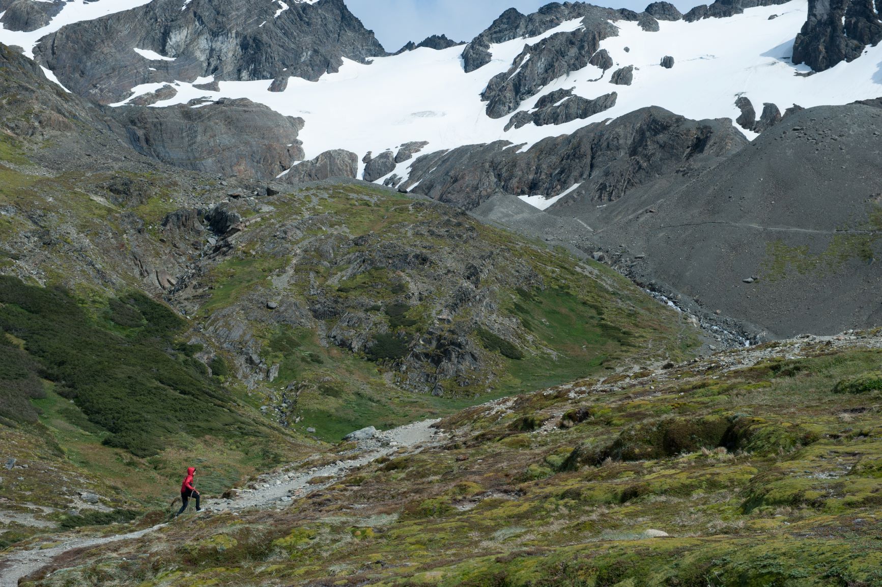
“Laguna Esmeralda” Trail
The trail begins 20 km from the city of Ushuaia, in “Sierra Alvear,” on the edge of National Route N° 3.
The path leading to the lagoon is also used by hikers on the “Ojo del Albino” Glacier trail, which is more difficult and exceeds the vegetation threshold. Much of the trail passes through recognized wetland areas, including peat bogs, mallines, and mires. At the beginning of the trail, the dominant vegetation is pure lenga forest, with prominent “stumps” that reflect past forest exploitation. Along the way, it is possible to observe the impacts on the environment and a large -currently inactive- beaver dam. Traveling through transitional environments between forest and peat, one reaches a high mountain environment, below the vegetation threshold in the area, which averages 600 meters above sea level.
- Difficulty: medium
- Duration: 2 hours
- Length: 4.5km
Main attractions: High altitude lagoon, “Esmeralda” River, view of the “Ojo del Albino” Glacier.
No admission fee is charged.
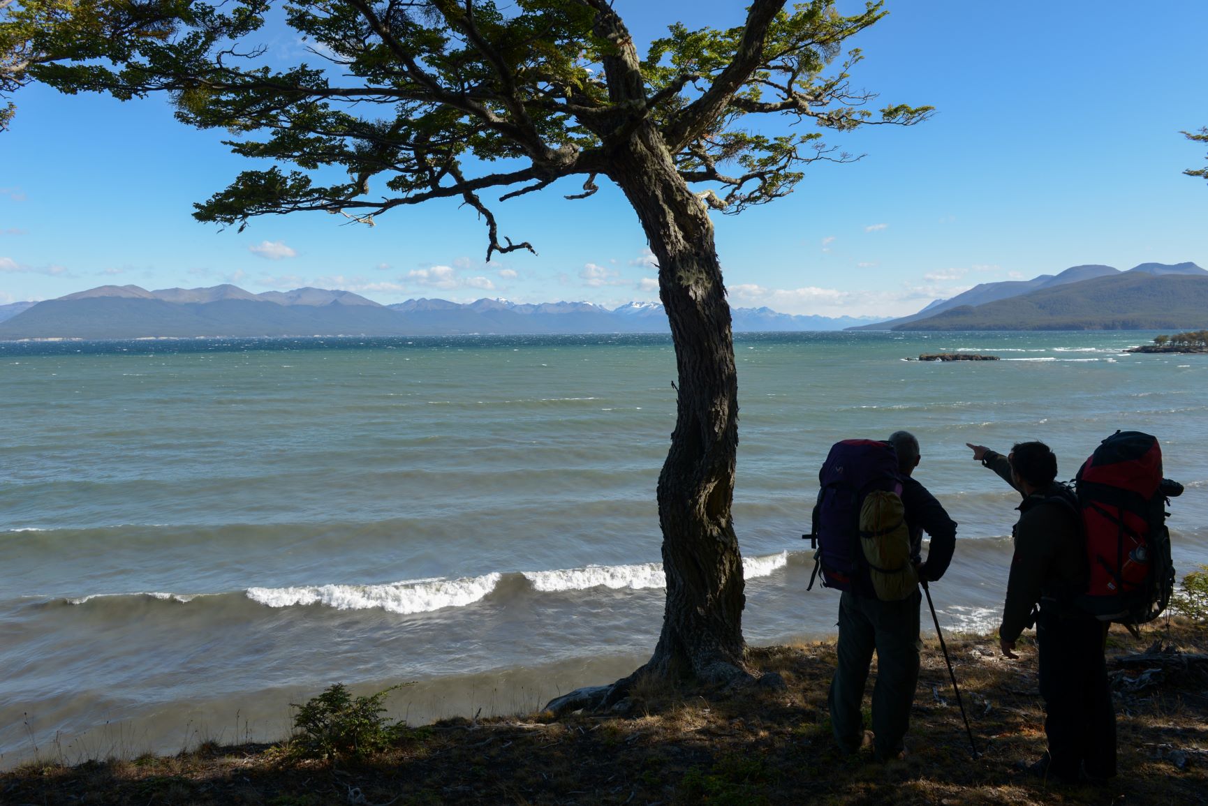
Vinciguerra Trail and “Laguna de los Témpanos”
The trail begins at the bottom of the Andorra Valley, after crossing the gate at the end of the road, where signs indicate we are in the right place. It crosses a large, mostly peat wetland, recognized as a RAMSAR site for its environmental importance, along with the Vinciguerra Glacier. The trail runs along the left bank of “Arroyo Grande”—the main water source for the city of Ushuaia—until crossing it over a bridge that takes us to the foot of a wooden plank. On the other side, we continue through the wetlands to enter the lenga forest. Within the forest, the trail is easy to walk, and only a few climbs will require a bit more physical effort, so it is recommended to ascend slowly. One kilometer from the bridge, we find the fork to “Laguna Encantada”, which from that point is approximately 1.5 kilometers (40 minutes one way).
Reaching the vegetation limit, upon leaving the forest, a transition zone opens up, dominated by a highland wetland, giving way to the beginning of the final steep climb that will take us—at a leisurely pace—to the shore of the “Laguna de los Témpanos,” where the Vinciguerra Glacier discharges its energy. The face of the glacier we see from there is laden with rocky material, known as moraine, that the ice mass has been carrying for many years. This material contributes a large amount of minerals to the water, giving it, among other characteristics, its characteristic color.
On the way back, you can see the distinctive features of these glacial valleys, with their more abrupt shapes, which we had behind us during the ascent.
It is recommended not to walk on the ice without technical knowledge or adequate equipment and/or without a guide.
Note: Some measuring elements (stakes) can be seen at both the source of the watercourse and on the glacier mass, which are used to monitor the behavior of the Glaciers and their relationship with the phenomenon of Climate Change. Please do not touch them.
- Difficulty: medium.
- Duration: 4.30 hours
- Distance: 6km.
Main attractions: Vinciguerra Glacier, “Laguna de los Témpanos”, RAMSAR Site, Andorra Valley, “Arroyo Grande.”
No admission fee is charged.
“Hacheros” Trail to Beban Waterfall (End of the World Trail)
The trail runs mainly along an old logging trail, well established as it allowed for the harvesting of lenga wood during the 1940s and 1950s, hence at various points along the way, you can see the “stumps” of trees that were cut down, remnants of this activity. Along the way, you will come across a rest area with tables and benches, and you will also find one before crossing the “Esmeralda” River bridge. The trail continues through the forest until it opens into the “Tierra Mayor” Valley’s peatland, which is primarily Sphagnum. After crossing the peatland, you re-enter the forest, where you will find storage sites for logs waiting to be transported to the city. The trail continues with some slopes that are gentler than others, ascending until you reach the Crossroads (or the point of the 3 trails), from where you can take the route east toward “Laguna Esmeralda” and “Tierra Mayor” (Lasifashaj River), or northeast toward the “Bonete” Refuge. But our path continues towards the NW to the left of “Cº Bonete,” from there it is almost 2km to the Beban Waterfall.

This section of the trail ends at the Waterfall, although you can continue north (with further preparation and logistics) towards “Paso Beban.”
- Difficulty: low.
- Duration: 1.30 hours
- Distance: 5.4km.
Main attractions: Beban Waterfall.
No admission fee is charged.
Lasifashaj River Trail (“Tierra Mayor”) to Beban Waterfall (Section 7 – End of the World Trail)
From the point where the Larsifashaj River cover sign is located, you can take the trail directly towards Beban Waterfall in a westerly direction. Only a short stretch to the east takes us to the camping area next to the river and allows the connection with the trail to “Laguna Submarino” (part of Section 8 – End of the World Trail).
After crossing the road and passing the “Tierra Mayor” Mountain Center, we can continue along the valley floor until we reach the forest line, where signs indicate the exact location to follow the trail within the forest, and a landscape of dense forest and openings to large peat bogs unfolds, providing an opportunity to appreciate the surrounding mountains. Several bridges facilitate crossing waterways. This section meets the trail to “Laguna Esmeralda” and overlaps it on the flat surface that crosses the peat bog of the “Tierra Mayor” valley. It then heads back toward the waterfall. After crossing the bridge over the “Esmeralda” River, pay attention to the signs, as this section also crosses the Pyrenean Forest Park (“PiPEF”).
The trail continues through the forest, gently gaining a little altitude. We reach the point identified as Crossroads (or the point of the 3 trails), from where we can take the trail to the “Bonete” Refuge, the exit to “Hacheros” Trail, which reaches approximately Km 17 of National Route 3. Our route continues to Beban Waterfall, where we continue until we cross a bridge that guides us northwest, leading us upwards, now outside the forested area, toward the end of the trail. We can observe the high-altitude peat bogs with their distinctive shapes and colors, as well as a different view of the Olivia River Valley and the Mount of the same name.
This section of the trail ends at the Waterfall, although you can continue north (with further preparation and logistics) towards Paso Beban.
- Difficulty: low.
- Duration: 2.30 hours
- Distance: 8.3km.
Main attractions: Beban Waterfall.
No admission fee is charged.
“Laguna Negra” Trail – “Landscape in motion”
Pedestrian access from the shore of lake Fagnano near the Hain Campsite, at Tolhuin, following the coast northward, walking for approximately 2,000 meters.
“Laguna Negra” is a coastal body of water separated from lake Fagnano by a gravel strip, created by a major seismic movement. It runs through a forest of lengas and ñires, passing through peat bogs, with a panoramic view of the “Peninsula del Viento.” Beaver dams and the consequences of the geological processes in the area can also be observed. Schwarz, Coronato and Acevedo (2013) highlight the geoenvironmental tourism potential of the Reserves: In the “Laguna Negra” Multi-purpose Provincial Reserve, you can see lakes, moraines and valleys originated by glaciers that no longer exist today, which account for global climate change; the southern limit of the South American plate that supports the Argentine national territory; and coastal lagoons resulting from the subsidence due to seismic activity at a plate edge.
- Difficulty: low.
- Duration: 2 hours
- Distance: 3.9km.
Main attractions: Peat bogs, ñire forests, Lake Fagnano.
Olivia River Trail (End of the World Trail)
The trail is accessed via National Route N° 3 – Río Olivia Wild Campsite. This is a very easy trail, intended to serve as a link between the trails in the city of Ushuaia and those that extend from the “Tierra Mayor” Valley. It runs from the campsite to the beginning of the “Hacheros” Trail (approximately Km. 17 of National Route 3), which would allow for a connection to the End of the World Trail and its many possibilities.
- Difficulty: low.
- Duration: 1 hour
- Distance: 3.8km.
Main attractions: Olivia River, Mount Olivia, filming site of the Oscar-winning film “The Revenant,” Carbajal Valley, Carvajal Viewpoint, “Tierra Mayor” Valley.
No admission fee is charged.
“Laguna Turquesa” Trail
“Laguna Turquesa” is located at the “Sierra Sorondo,” and its access is very close to the city of Ushuaia. The trail follows an old lumberjack path, so old cuts and marks on the trees are visible. Although the trail is well-marked, it is classified as a medium-level hike due to its steep gradient, making it difficult for hikers during snowy or rainy seasons. Outside the vegetation line, there are views of “Sierra Alvear” and “Laguna Esmeralda.”
Other interesting information: For much of the trail, you walk along the edge of the stream that originates in “Laguna Turquesa.”
Main attractions: “Sierra Sorondo,” “Sierra Alvear,” “Laguna Esmeralda,” “Laguna Turquesa,” Olum Valley.
- Signposted trail.
- Duration: 3 hours.
- Difficulty: Medium.
- Length: 3km.
“Cascada” and “Laguna Submarino” Trail
This is a trail at which we can identify two distinct stages: the first is of “low” difficulty, takes an hour and a half to reach the waterfall and runs entirely through the forest, crossing some wetland areas.
The second stage, which is of “medium” difficulty, requires greater physical effort. It involves climbing a several-meter rock wall where ropes assist both the ascent and descent.
Once outside the vegetation limit, you walk through rocky areas that, at certain times of the year, may be covered in snow or ice. There are some stone walls and stakes marking the southbound route, where “Laguna Submarino” is located.
In both stages, the use of boots, a coat and waterproof clothing is essential.
Other interesting information:
Entrance: 20 km from the city of Ushuaia, opposite the “Tierra Mayor” Mountain Center – on the way to the gas pipeline. One kilometer from the entrance, near the Lasifashaj River, there is a wild camping area with fire pits.
The name comes from the shape of the hill where the lagoon is located, which, from a perspective, resembles a submarine.
Main attractions: “Tierra Mayor” Valley, Lasifashaj River, “Laguna Submarino.”
- Signposted trail.
- Duration: 7 hours.
- Difficulty: Medium.
- Length: 12km.
“Laguna de los Perros” and “Laguna Fiel” Trail
To access the trail, travel north on National Route N° 3. One kilometer past the Garibaldi Pass viewpoint, you will come across a sharp curve, known as “La Herradura.” There is a small parking lot to the right.
While the trail ascends along steady, gentle slopes, it also passes through sections of slopes with rocks, mud, and exposed roots, as well as very wet areas that require the use of hiking boots to avoid accidents.
The last few meters are covered above the vegetation limit until the two high-altitude lagoons can be seen.
Other interesting information:
For much of the path you will walk along the edge of the stream that flows down from “Laguna de los Perros.”
- Signposted trail.
- Duration: 4 hours.
- Difficulty: Medium.
- Length: 5.8km.